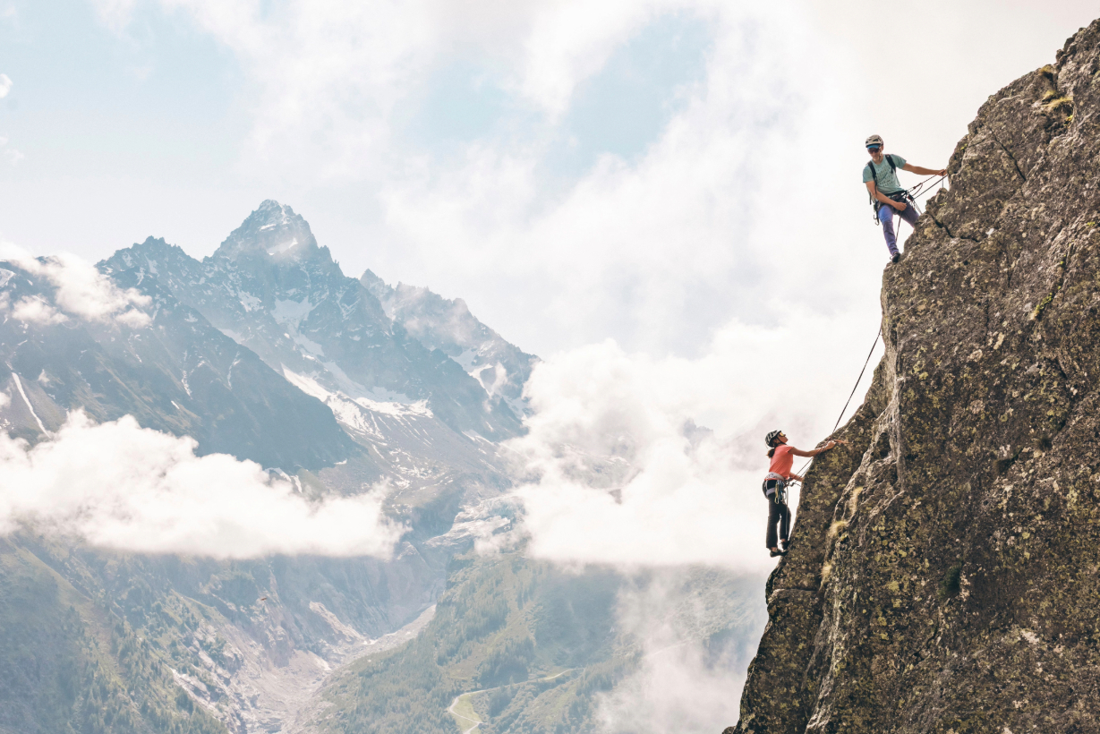
A Snell Sports x Whympr Evening to Discover Climbing Differently
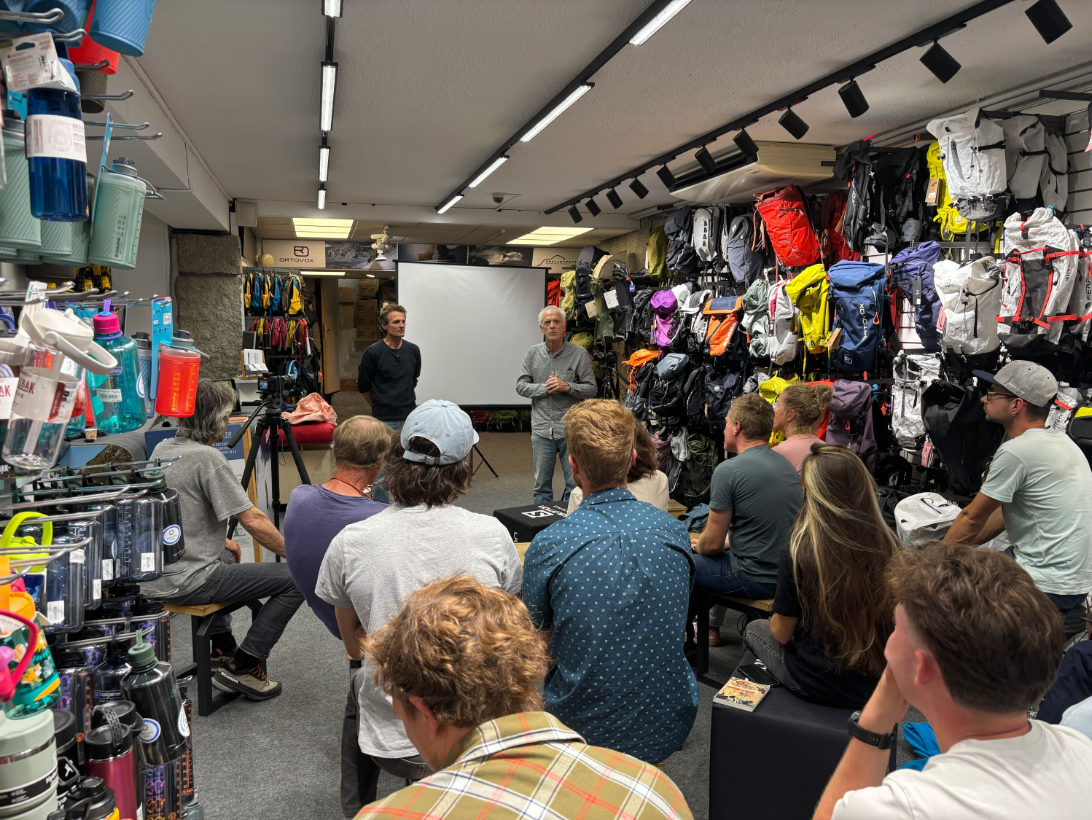
On July 29, 2025, Whympr hosted an evening at Snell Sports in Chamonix with route setters, big-wall openers, and guidebook authors. A topic close to our hearts—climbing’s behind-the-scenes work often goes unnoticed, even though we all benefit from the effort put into route setting and guidebook writing.
Gilles Brunot (EKIPROC editions), who has rebolted many crags and authored guidebooks for the Vallée de l’Arves, Aravis, and Giffre/Risse/Foron, along with François Burnier, co-founder of Vamos guidebooks with Dominique Potard, route opener, and mountain guide, were on hand to share their work. It was a great chance to get to know this side of climbing, pick up tips, and swap stories in a friendly atmosphere.
The Vamos editions are now part of the same company as Whympr and Iphigénie. These guidebooks are available digitally on Whympr. Gilles Brunot was one of the first authors to digitize his guidebooks on Whympr, available for purchase under the name Topo Pro.
It’s always a pleasure to host events at Snell Sports! A reference shop in Chamonix for all mountain gear, it’s the perfect place to talk climbing. Quick reminder for Snell Sports customers: if you’re a Whympr Premium subscriber, you get 10% off everything in the store and 15% off rentals.
For anyone who couldn’t make it to Chamonix that day, here’s a recap of the evening
François Burnier, Guide and Founder of Vamos Editions
The First Climbing Guidebooks of the Chamonix Valley
For a long time, the only climbing guidebooks in Chamonix focused solely on high-altitude routes. Some climbs in the Aiguilles Rouges were described, but nothing lower down. Gaston Rébuffat’s The 100 Greatest Climbs was the go-to reference for climbing and mountaineering. And for good reason: this classic book, written in 1973 by the great French alpinist, presents his selection of Mont Blanc massif climbs. It’s inspiring, but these challenging routes are mostly in the high mountains (though a few are in the Aiguilles Rouges).
Other well-known guidebooks for locals were the Vallot guides, first published between 1925 and 1938. These were purely descriptive, without any photos or diagrams. Reprinted over the years, they lasted until the 1980s before becoming obsolete—but they remain highly prized by collectors.
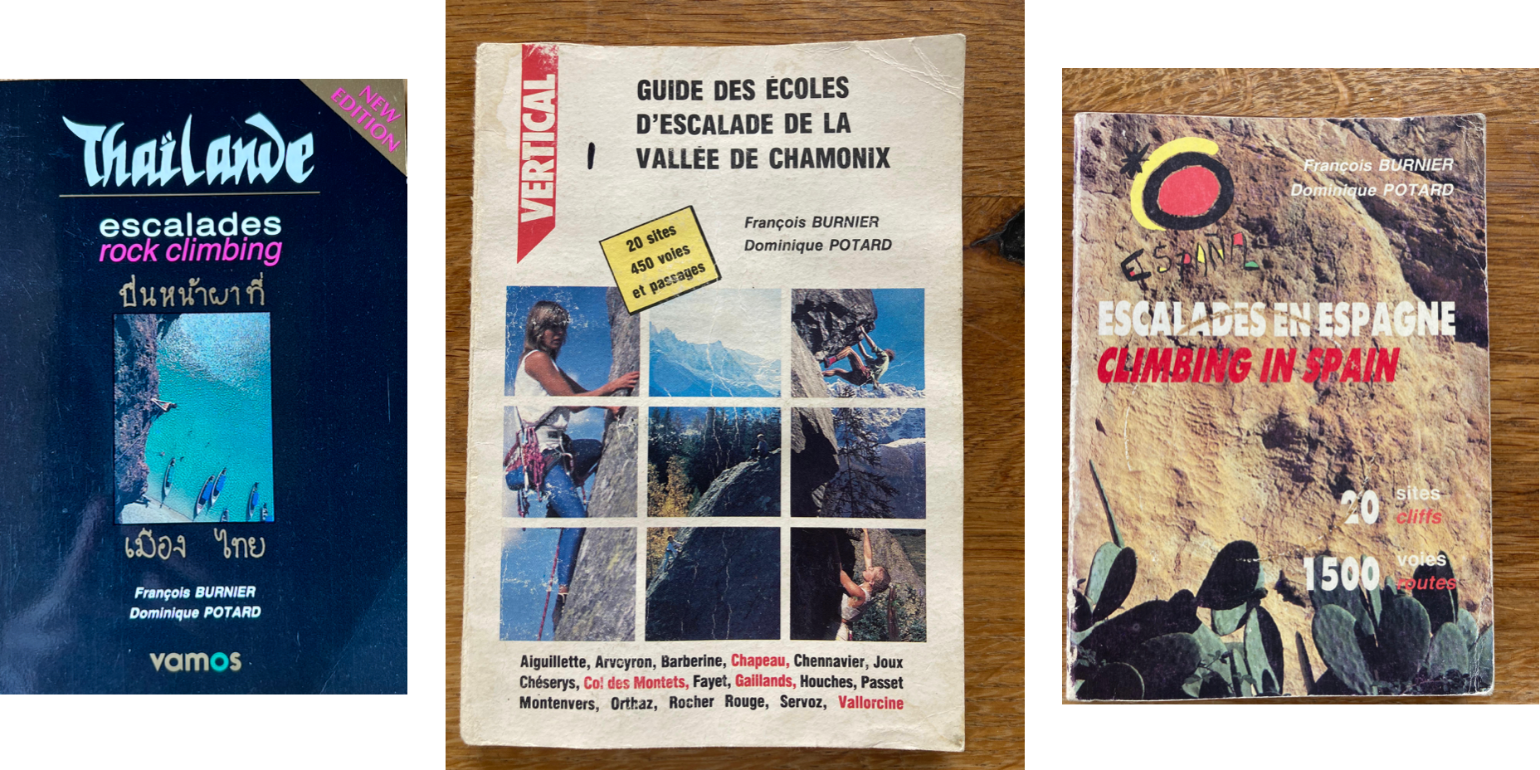
But what about all the lower-altitude crags and multi-pitch routes around Chamonix? That’s the gap that guides François Burnier and Dominique Potard noticed. In 1986, they published the first guidebook covering Chamonix’s lower-altitude sport and multi-pitch climbing routes.
Not professional publishers, they raised some funds from 3 local stores (Snell, Sanglard, Stamos). They contacted an Italian printer near Morgex, who still prints the current Vamos guidebooks today. The book was a success, and an English version followed quickly.
Ambitious Guidebook Projects Followed
In 1987–1988, they published a climbing guide for Spain. François and Dominique sometimes spent six months there, giving them plenty of time to know the areas well and describe them accurately. Of course, the book isn’t exhaustive—Spain has so many incredible climbing spots! The idea was to present enough routes to fill a 4-day trip, from 5/6a for beginners to 7 for stronger climbers.
Next came the idea of climbing in Thailand and creating a guidebook there. This book, beautifully designed with illustrations and gold accents, was translated into Thai so locals—the ones most concerned—could use it. Petzl and UCAP supported them on this project.
Over time, Vamos Editions became a reference in the climbing world. By diversifying and focusing on generally accessible routes, their guidebooks were designed not just as directories but as invitations to explore the mountains.
Vamos Editions Today
Since Dominique Potard stopped working on the guidebooks in 2005, François decided it was time to pass the torch. That’s how Whympr acquired Vamos Editions in 2023—to continue publishing and creating new print guidebooks, while also making them available digitally in the Whympr app.
If you want to learn more about this handover, check out our blog post detailing Whympr’s acquisition of Vamos Editions. François still collaborates on updating existing books and writing new ones.
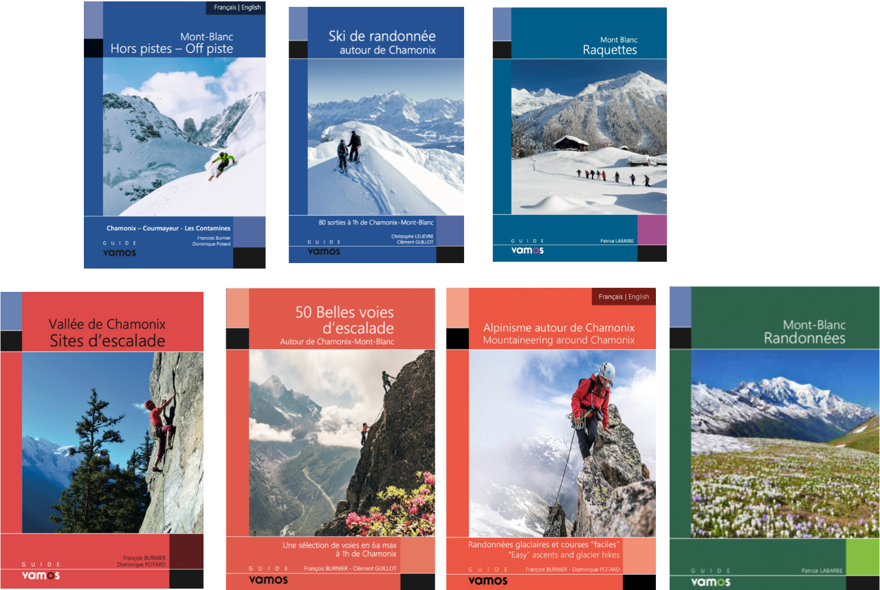
For example, this summer saw the release of a brand-new Vamos climbing guide, written by François and Clément Guillot, featuring a selection of 60 multi-pitch routes in and around Chamonix. All routes are equipped and don’t exceed 6a (except for a few that require just a few nuts).
Last year also brought new mountaineering and ski touring guidebooks for the Chamonix area. The grades don’t exceed AD, keeping the spirit of mountain exploration alive. This year, a backcountry skiing guide around Chamonix was also released.
Let’s not forget: publishing guidebooks often helps fund route development and maintenance. Just like with a printed book, when you buy a Topo Pro on Whympr, a percentage of the profit goes back to the author—who can use it, among other things, to install new bolts.
Vamos has long supported climbers wanting to equip routes in Chamonix. Today, François has relaunched the Servan association to help new route setters by providing them with gear.
Now, when you buy a Vamos guide, you also get the digital version for free in Whympr. This way, you enjoy the benefits of both print and digital. For instance, for mountaineering, hiking, snowshoeing, ski touring guides, or the essential book of the best mountain huts with views of Mont Blanc, you’ll get access to the GPX tracks for each route.
Another major advantage of Topos Pro in Whympr is that they’re updated continuously—no need to wait for a new edition. To access your Topos Pro after buying a Vamos guide, just scan the QR code at the start of the book. You’ll find all the info you need.
All guidebooks are available on the Vamos Editions website.
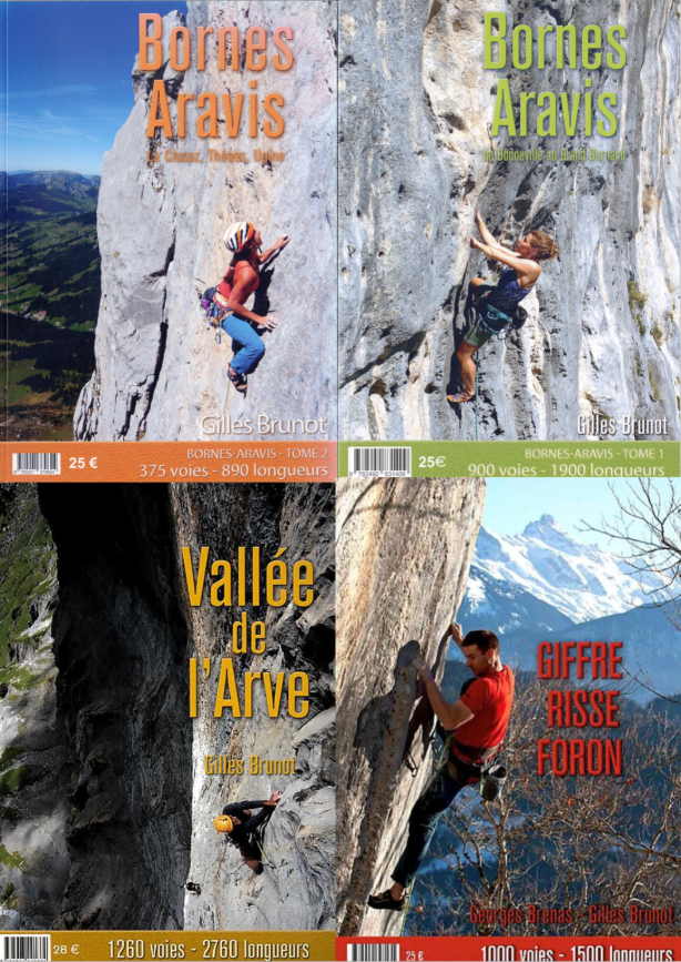
Gilles Brunot: Haute-Savoie’s Most Prolific Rebolter and Author of the Vallée de l’Arves, Aravis, Giffre/Risse/Foron Guidebooks
How to Make the Most Complete Guidebooks
If you climb in Haute-Savoie, you’ve probably already held Gilles Brunot’s guidebooks from EKIPROC editions. They’re the go-to reference for the Vallée de l’Arves, the Aravis, and the Giffre/Risse/Foron valleys—up-to-date, comprehensive, and packed with essential info to help you choose the right crag or multi-pitch route.
Gilles was one of the first authors to enter his climbing guides into Whympr. His attention to detail inspired us to develop this concept. He inputs the data himself, updating cliffs and multi-pitch routes as he goes.
A climbing enthusiast, Gilles started by opening multi-pitch routes in Belfort—not with a drill, but with a hand auger. By late ’87, he was already hanging on a rope, setting routes at La Maladière. Back then, there was no up-to-date guide for the Vallée de l’Arves. To share his routes, Gilles and Denis Cardot decided to write a guidebook for the Vallée de l’Arves, published in 1992. The first reprint came out in 1997. Five years later, the Vallée du Risse was added in a color edition with vector drawings and analog photos. Pictograms were also added (route lengths, climbable in the rain, etc.).
Not all cliffs can be photographed. Vegetation often gets in the way, and taking pictures from the base rarely works. For example, the Vuardes cliff was photographed from Carroz d’Arâches, several kilometers away—something rarely possible in Haute-Savoie—hence the use of sketches.
To accurately represent cliff dimensions, Gilles measures routes to the meter by climbing them, then stretches a tape at the base to measure horizontal distances. For the Pierre à Laya cliff, it took him five days of measurements just to complete the drawing.
In addition to the Vallée de l’Arves and Giffre/Risse/Foron guides, Gilles published two volumes covering the cliffs and multi-pitch routes of the Aravis. The Vallée de l’Arves guide was becoming too large—especially with the addition of the Bargy cliff. Gilles then approached the publishers of the Aravis guides to propose his own edition, covering the whole Aravis massif. They agreed on the condition that he cover the entire area.
With each new edition, additional data was added (climbable in light/heavy rain, suitable for kids, number of quickdraws, environmental quality, approach time, type of effort, etc.). This meant many routes had to be reclimbed. The more information included, the faster guides become outdated.
Gilles eventually embraced digital guidebooks, inputting all his routes into Whympr himself, available for purchase individually or as a pack.
The Art of Rebolting
Gilles created an association called EKIPROC, which also functions as a publishing house. This is how the guidebooks are sold and how climbing gear can be purchased.
While Gilles does most of the rebolting himself, other route openers in the valley can request equipment. Opening a multi-pitch route is a very long process. For example, when opening Bételgeuse on Pointe d’Ayère in the Fiz, the wall was almost untouched (except for a few routes in natural weaknesses), making it hard to judge the rock quality. Climbing the Pérrilat/Sanchez route at L’Enclume a few years earlier, Gilles had learned that although the base was questionable, the upper pitches were solid rock.
In February 1999, after the Mont Roc avalanche, Gilles—an avalanche risk specialist—was flown by helicopter above the Assy plateau. He took a small detour to check out Pointe d’Ayère and, together with Pierre Gourdin, decided to open the route from the bottom. They later returned to open Dré dans l’pentu, also on Pointe d’Ayère.
Generally, it’s easier to open a route from the top. But be careful—anchoring the rope at the summit can be complex and dangerous. It’s hard to know your exact position while rappelling, and the rope often has to be moved multiple times to find the right spot.
Opening from the bottom requires reading the route as you go. Dead ends are common. Climbers often have to hang on temporary hooks, hoping they hold. Sometimes you can place cams or pitons—but that wasn’t possible at Pointe d’Ayère. Once securely positioned, the drill must be hoisted to place the expansion bolt, which you can clip into and use immediately.
There are two main types of permanent anchors:
- Expansion bolts: Once placed, you can immediately clip and climb. But they have downsides: they can unscrew, water can get inside (causing freeze/thaw issues in high mountains), and on fragile rock, the bolt can put pressure on the rock.
- Epoxy anchors: Longer to install. The hole must be cleaned and drilled to the exact length, then glued using cartridges (making sure the resin is properly mixed) or hard Sika.
Placing anchors requires considering many factors: proper clip placement, solid rock, avoiding holds, and, of course, the cost.
Every cliff is on private land—sometimes communal, sometimes privately owned. Until three years ago, landowners were legally responsible for accidents on their property. The FFME (French Climbing Federation) would sign agreements to assume liability. However, an accident in the Pyrénées-Orientales ended up being very costly for insurers, so the FFME canceled all agreements for those cliffs. Haute-Savoie wasn’t really affected because most cliffs are on communal land and not under formal agreements.
For a full list of cliffs covered in Gilles’ guidebooks and those available in Whympr, check out his website: escalade74.

Whympr: The App to Find Gilles Brunot and Vamos Editions Guidebooks
Topos Pro: All Paper Guidebooks in Digital Form
Guidebooks are a must-have for climbers. Perfect for flipping through to find inspiration, checking large-format sketches, and building a personal library of all the areas you’ve explored. At Whympr, we believe digital and paper guidebooks complement each other—they can’t replace one another. Just like a phone map should be paired with a paper map in your backpack, digital guidebooks go hand in hand with paper versions.
From the very beginning, the idea of Topos Pro, written by professionals, became essential for planning mountain outings.
Topos Pro are the digital versions of paper guidebooks—like those by Gilles Brunot or Vamos Editions—available directly in the Whympr app. Unlike community-generated route descriptions on platforms like CamptoCamp or SkiTour, Topos Pro are authored by professionals and available for purchase. Every Topo Pro purchase supports the authors, with a percentage of the proceeds often going toward maintaining climbing areas, as François and Gilles mentioned earlier.
Whympr offers a wide selection of Topos Pro. You’ll find guides for climbing around Chamonix, but also for other areas like the Verdon Gorge or the Calanques. There are also Topos Pro for other activities, such as hiking, ski touring, and mountaineering.
This digital format lets you bring just your phone to the cliff, without needing to carry the physical book in your backpack. You can buy the entire Topos Pro pack (equivalent to the full book) or purchase individual routes or sectors—perfect for short trips where the full pack isn’t necessary.
For certain activities—like hiking, ski touring, or mountaineering—Topos Pro even include the GPX track of the route. Of course, you should never follow a GPS track blindly in the mountains, but it’s always helpful to visualize the route before heading out.
Some Topos Pro are also available in English.
Since Whympr acquired Vamos Editions, buying a Vamos guidebook gives you free access to its Topo Pro version in Whympr. This offer applies to all Vamos books, not just climbing guides. Inside the first pages of each book, you’ll find a QR code and instructions to access Topos Pro. You’ll need a free Whympr account to get access.
Topo Pro Pricing in Whympr:
- €1.99 for a single route or itinerary
- €3.99 for a sector
- €9.99 for an entire chapter
- €19.99–€29.99 for the full book, depending on its size
Here’s a (growing) list of climbing Topos Pro available in Whympr, with more coming thanks to new agreements with other authors:
- Gilles Brunot: Vallée de l’Arve, Bornes Aravis Tome I & II, Giffre/Risse/Foron (EKIPROC editions)
- Vamos Editions: Vallée de Chamonix guides, climbing sites, and 50 Great Routes Around Chamonix-Mont-Blanc (plus many other guides for different activities)
- François Damilano, Louis Laurent & Julien Désécures: Mont-Blanc Granite Tome II (Aiguilles de Chamonix, JMEditions)
- Brunot Clément (aka Graou): Verdon Inté'Graal (CQFD editions)
- VTOPO Editions: Calanques Escalade, Beldonne Escalade, and Le Destel Montagne de Toulon
For more info on Topos Pro, check out this blog post and our YouTube tutori
The Complete Climbing App
Beyond Topos Pro, Whympr brings together other tools to help you plan your climbing trips. By integrating various community databases, such as CampToCamp or Guliver for climbing, Whympr now includes over 100,000 routes and points of interest.
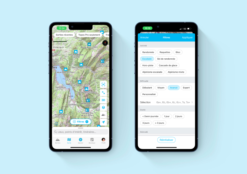
To find a specific route or summit, just use the search bar and type the name. You can also explore the map, where you’ll see all points of interest—cliffs, summits, boulders, etc. To show only climbing spots, use the “climbing” filter so that only cliffs appear.
For even more precise results, choose your level in the filters (beginner, intermediate, advanced, expert) so only routes at your level are displayed.
By enabling geolocation on the map, you can see climbing areas near you—perfect for discovering new spots or planning when you’re on vacation! Whympr combines tools for all outdoor activities, so you can use it for climbing, ski touring, mountaineering, or hiking. Thanks to MeteoBlue, you’ll also have weather forecasts for each point of interest, four days back and four days forward.
Check the activity feed to see recent outings and get inspired. If you’re only interested in climbing, you can filter the feed to show only climbing activities.
Whympr also provides access to 23,000 webcams worldwide—perfect for checking whether a cliff is dry. From there, it’s up to you to use the tools as you like: maps, layers, BERA, or your profile, where you can create a climbing log.
Whympr is a freemium app. The basic version is free, while the Premium version gives you access to all features. Premium costs €14.99 for three months or €29.99 for a year. You can try Premium free for three days. If you decide not to continue with a paid subscription after the trial, remember to cancel it in your AppStore/PlayStore profile.
Important: Topos Pro are not included in Whympr Premium. They work like physical guidebooks, with a portion of the proceeds going directly to the authors.
Grab your climbing shoes, helmet, harness… and maybe your drill?
As François points out, lots of climbers start writing their own guidebooks. Are you one of them? Do you climb and notice a few blank lines you’d love to develop? Are you the type who always carries a wrench to tighten a bolt or a bit of cord to reinforce an anchor?
Who knows—maybe one day you’ll dive into writing your own climbing guide! If that happens, don’t forget to give us a call—we’ll definitely be able to help 😉
Finally, we can all help take care of the cliffs.
Even if you’re not getting into the complex work of rebolting, it’s important to pitch in by clearing brush and cutting away obstructive vegetation. And remember—if you ever plan to rebolt a route, always contact the original openers to respect the spirit in which the route was created.
We’d like to thank Snell Sports for hosting us. If you’re in Chamonix, don’t hesitate to stop by—they’re offering 10% off everything in the store (15% off rentals) for Whympr Premium members.
There are still a few months left to climb this season, so let’s make the most of it—and don’t forget your guidebooks!
See you soon on Whympr or at the crag! Download Whympr for free now on the App Store and Google Play. ⛰️


